Viewing Entries 1 - 2 of 2
Page
1 |
| Image |
Title
Description |
Object
Date |
Accession # |
Location |
|
More Info
|
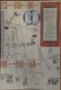
C M & S & Kimberley Area Yard
Map showing F & G yards in Kimberley, BC. Details include station, Fertilizer Plant, Freight Shed and round house. |
technical drawing : plan, photocopy
March 1966 |
1981.008.001 |
2-6-2-3 |
|
Hand drawn Map Wilcum Leith depicts
Cranbrook-Kimberley-Wasa: The McGinty Wagon Road to the Northstar mine.
Short history of CPR by Sir Donald Mann
Wooden frame |
Framed Print
|
2005.002.001 |
3-Dimensional |
Viewing Entries 1 - 2 of 2
Page
1 |